Anomalously large latent heat fluxes in low to moderate wind conditions within the eddy-rich zone of the Northwestern Pacific
Sok Kuh Kang*, Eun Jin Kim, Sunghun Kim, Joseph Cione, Dongkyu Lee, Sebastian Landwehr, Hyoun-Woo Kang, Kyeong-Ok Kim, Chang Su Hong, Min Ho Kwon, Kyung-Hee Oh, Jae Hak Lee, Suyun Noh, Jae Kwi So, Dong-Jin Kang, Dongseon Kim, Jae-Hyoung Park, SungHyun Nam, Yang Ki Cho, Brian Ward, Isaac Ginis
Published in Frontiers in Marine Science, February 2024
An air-sea interaction field campaign was conducted in September of 2017 within the warm and cold eddy region of the western Northwest Pacific (WNP) (17.5˚-20.5˚N, 127.5˚E-133.5˚E). Both near-surface oceanic and atmospheric conditions in addition to ocean heat content (OHC) were examined to better understand the mechanisms governing high heat flux magnitudes responsible for rapidly intensifying tropical cyclones. Observations from this experiment indicate that the latent heat flux (LHF) under modest wind conditions reached 400 W m-2 within the vicinity of a warm eddy, with OHC higher than 100 kJ cm-2 of warm eddy region being 2~3 times as large as that of cold eddy region. These high OHC and a resultant high LHF in the warm eddy, comparable to the magnitude of LHF in the North Equatorial Current, may explain the mechanism of why tropical cyclones over a warm eddy in eddy-rich zones often rapidly intensify in the WNP. A month later typhoon Lan rapidly intensified into a super typhoon, while passing over the boundary region of warm and cold eddies during the observation period. Results from this study illustrate that both the wind-normalized LHF and the difference (Qs-Qa) between the specific humidity at air (Qa) and at the sea surface (Qs), closely correlate with OHC patterns, which suggests that the ocean looks likely to control the spatial pattern of LHF. Overall, both the ocean and weather conditions govern the pattern of specific humidity difference between the air-sea interface, with large OHC over the warm eddy controlling higher Qs and the pattern of Qa depending on the pattern of wind direction. Qa as a factor impacting LHF magnitude is strongly linked to wind direction in the experimental area, that is, the drier northwesterly flow and southeasterly moist wind, resulting in the enhanced contrast of specific humidity at cold eddy region.
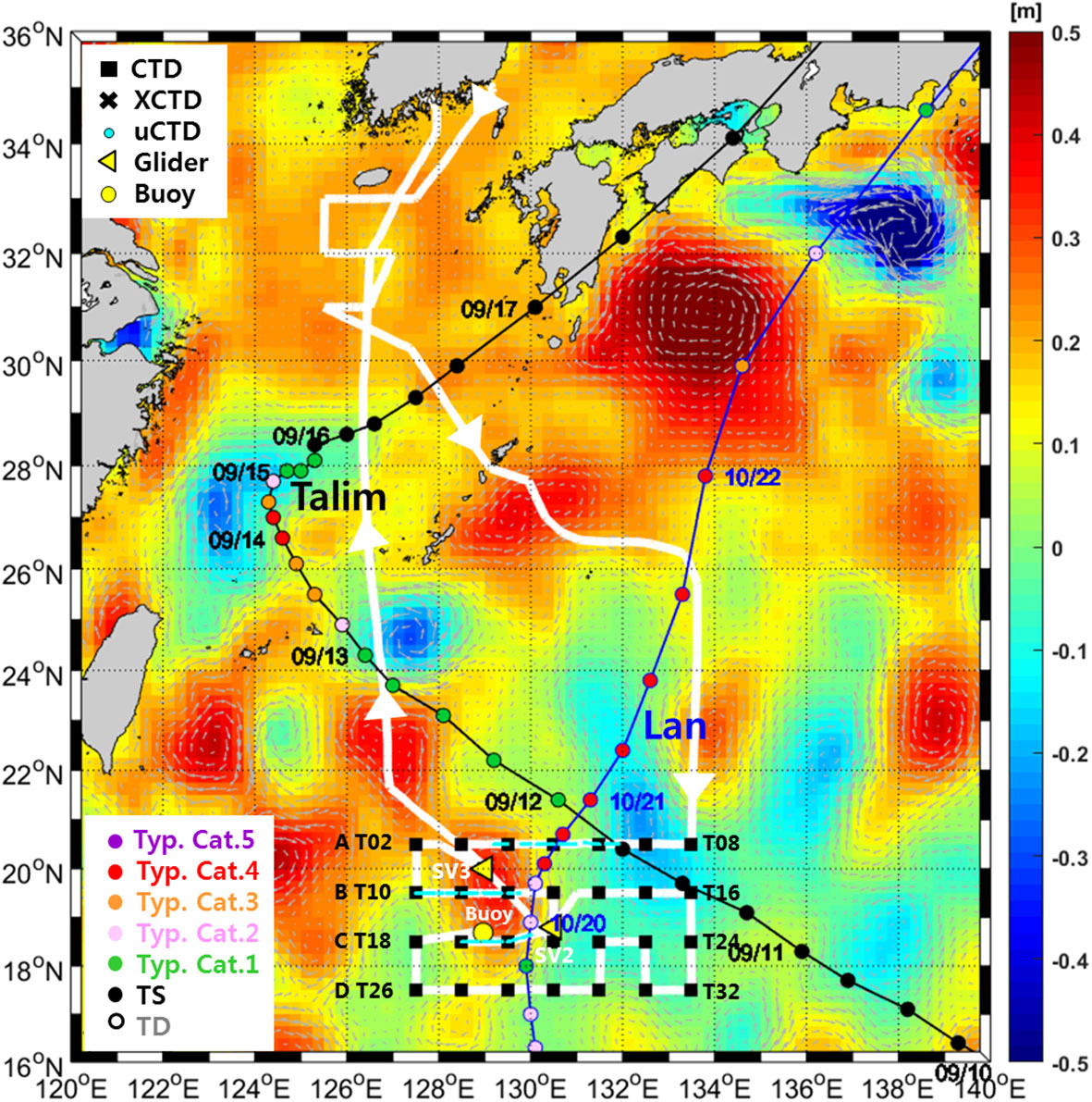
Figure. Field experiments along the ship track (thick white line) were carried out from Sep.14 to 25 in the NWP. CTD (rectangular points), uCTD points (sky-color linelike points) are seen, and radiosondes are deployed on every CTD casting point. Yellow triangle points denote the locations of two wave gliders (SV2 and SV3) deployed. Air temperature, air pressure, and relative humidity data with 1Hz sampling are continuously measured from various sensors attached to the bow of the R/V Isabu at approximately 10 m height above the sea surface. Tracks of typhoons Talim and Lan are denoted by solid lines with dates when TC passes through the location. The colors on the tracks denote the intensity of TC (green color of category 1 to red color by category 4) from the best track data from the Joint Typhoon Warning Center (JTWC). Station numbers are written only at western and eastern points. The background color denotes the sea surface height anomaly (m) on Sep.15, from the Copernicus website. The station number of CTD is 30 and the number of uCTD is 163.
Kang, S., Kim, E., Kim, S., et al. Anomalously large latent heat fluxes in low to moderate wind conditions within the eddy-rich zone of the Northwestern Pacific. Frontiers in Marine Science, 11.https://doi.org/10.3389/fmars.2024.1298641