Pacific North Equatorial Current bifurcation latitude and Kuroshio Current shifts since the Last Glacial Maximum inferred from a Sulu Sea thermocline reconstruction
Thomas L.Weiss, Braddock K.Linsley, Arnold L. Gordon
Published in Quaternary Science Reviews, July 2021
The meridional migration of the bifurcation latitude of the Pacific North Equatorial Current (NEC) in the western boundary of the tropical Pacific modulates the strength of the Kuroshio Current. Using salinity reanalysis data, we show the NEC bifurcation latitude also acts as the dominant control on thermocline salinity of the Sulu Sea, just west of the Philippine archipelago, by regulating influx of western Pacific thermocline water via the Luzon Strait. We used oxygen isotopes (δ18O) and Mg/Ca in the thermocline-dwelling foraminifera Globorotalia tumida from Sulu Sea sediment core MD97-2141 to determine past thermocline δ18Ow and salinity variability spanning ∼20–5 ka with an average sampling interval of ∼50 years and infer past changes in the NEC bifurcation latitude. Our Sulu Sea thermocline reconstruction reveals high salinity from ∼18.8–15.5 ka, ∼12.2–11.5 ka, and from ∼9.5–8.5 ka indicating the NEC bifurcation latitude was shifted north and the Kuroshio was weak at those times. Low Sulu Sea thermocline salinity from ∼13.0–12.4 ka, ∼11.5–10.9 ka, and from ∼8.5 ka until the end of the record at ∼5.6 ka indicates the NEC bifurcation latitude was shifted south and the Kuroshio Current was relatively strong. Comparison to other paleoclimate records suggests the observed northward (southward) shifts of the NEC bifurcation latitude were driven by southward (northward) shifts of the Indo-Pacific ITCZ, consistent with modern mechanisms controlling interannual NEC bifurcation variability. The NEC bifurcation latitude shifts likely modulated northward energy transport via the Kuroshio Current and the mean temperature and salinity of the Indonesian Throughflow.
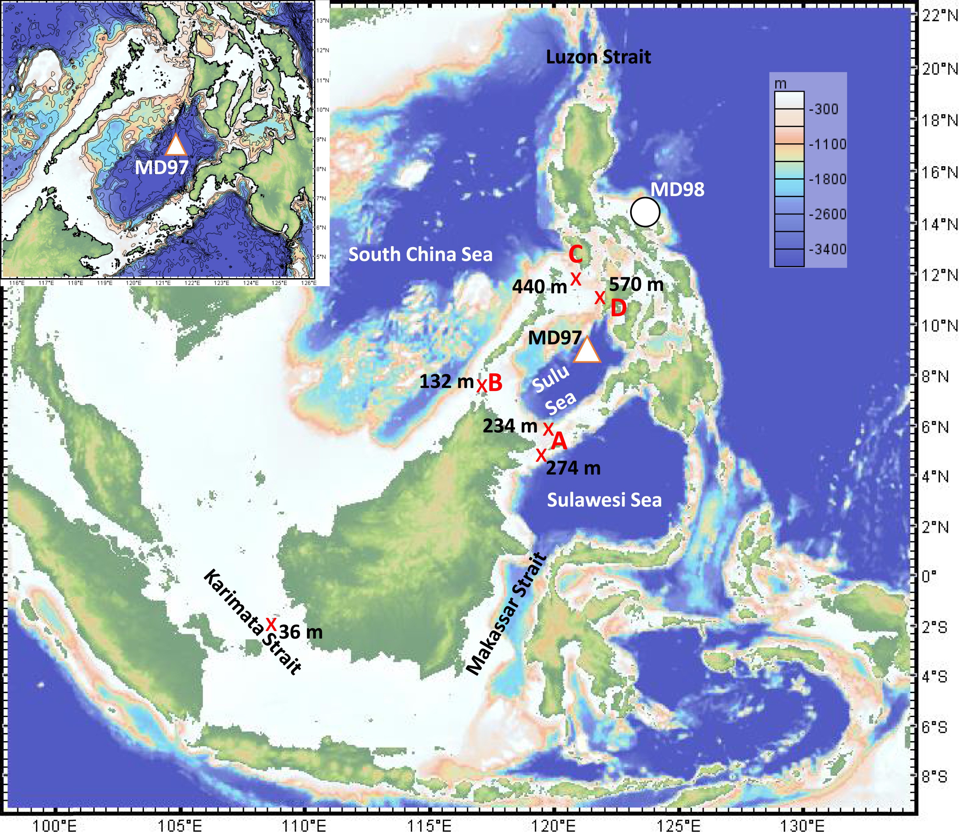
Fig. Location and bathymetry of the Sulu Sea in relationship to Indonesian region. X's indicate the location and depth of the shallowest points of the deepest routes water must pass to ventilate Sulu Sea deepwater and the Karimata Strait. Approximate coring locations are shown for core MD97-2141 (white triangle with orange border) and MD98-2188 (white circle with black border). A: Sibutu Passage B: Balabac Strait C: Mindoro Strait D: Panay Strait. Figure was made using the GeoMapApp: http://www.geomapapp.org (Ryan et al., 2009). Bathymetric shading is from the Global Multi-Resolution Topography synthesis (GMRT) (Ryan et al., 2009) and are consistent between panels. Sulu Sea strait depths are from Gordon et al. (2011) and Karimata Strait depth is from Wang et al. (2019).
Weiss, T., Linsley, Braddock, and Gordon, A. (2021). Pacific North Equatorial Current bifurcation latitude and Kuroshio Current shifts since the Last Glacial Maximum inferred from a Sulu Sea thermocline reconstruction. Quaternary Science Reviews, 264, 106999, https://doi.org/10.1016/j.quascirev.2021.106999.