Germineaud, C., Cravatte, S.; Sprintall, J.; Alberty, M. S.; Grenier, M.;Ganachaud, A.
Published in DEEP-SEA RESEARCH PART I, MAY 2021
In the South Pacific Ocean, upper and lower Circumpolar Deep Water (UCDW and LCDW, respectively) occupy the deep layers; however, the presence and fate of these two water masses in the western equatorial Pacific have been mostly based on sparse measurements in both space and time. In this study, unprecedented deep measurements from three cruises conducted in the Solomon Sea region along with the World Ocean Database 2018 are examined to better characterize the properties and pathways of deep water in the Southwest Pacific. At depths encompassing most of UCDW, estimated transports derived from two inverse model solutions indicate interbasin exchanges between the Solomon Sea Basin and the Coral Sea Basin to the south, and the East Caroline Basin to the north. The deep water transport variability found across the Solomon Sea is consistent with observed water mass modifications due, for the most part, to diapycnal mixing. At depths greater than about 2600 m, deep water inflow into the Solomon Sea Basin is limited to the south, emanating from the Coral Sea remote basins via complex trench topography. Spreading of LCDW in the Coral Sea and subsequently into the Solomon Sea is blocked by the Tonga-Kermadec Ridge to the east and bottom topography to the south, however, the densest part of UCDW entering both the Coral and Solomon Seas is likely influenced by LCDW properties, as oxygen is found to increase and silicate decrease with depth in the region. Waters trapped in closed deep basins, in the Bismarck Sea below 1750 m and the northern Solomon Sea below 3500 m show a remarkably constant pattern in oxygen with depth.
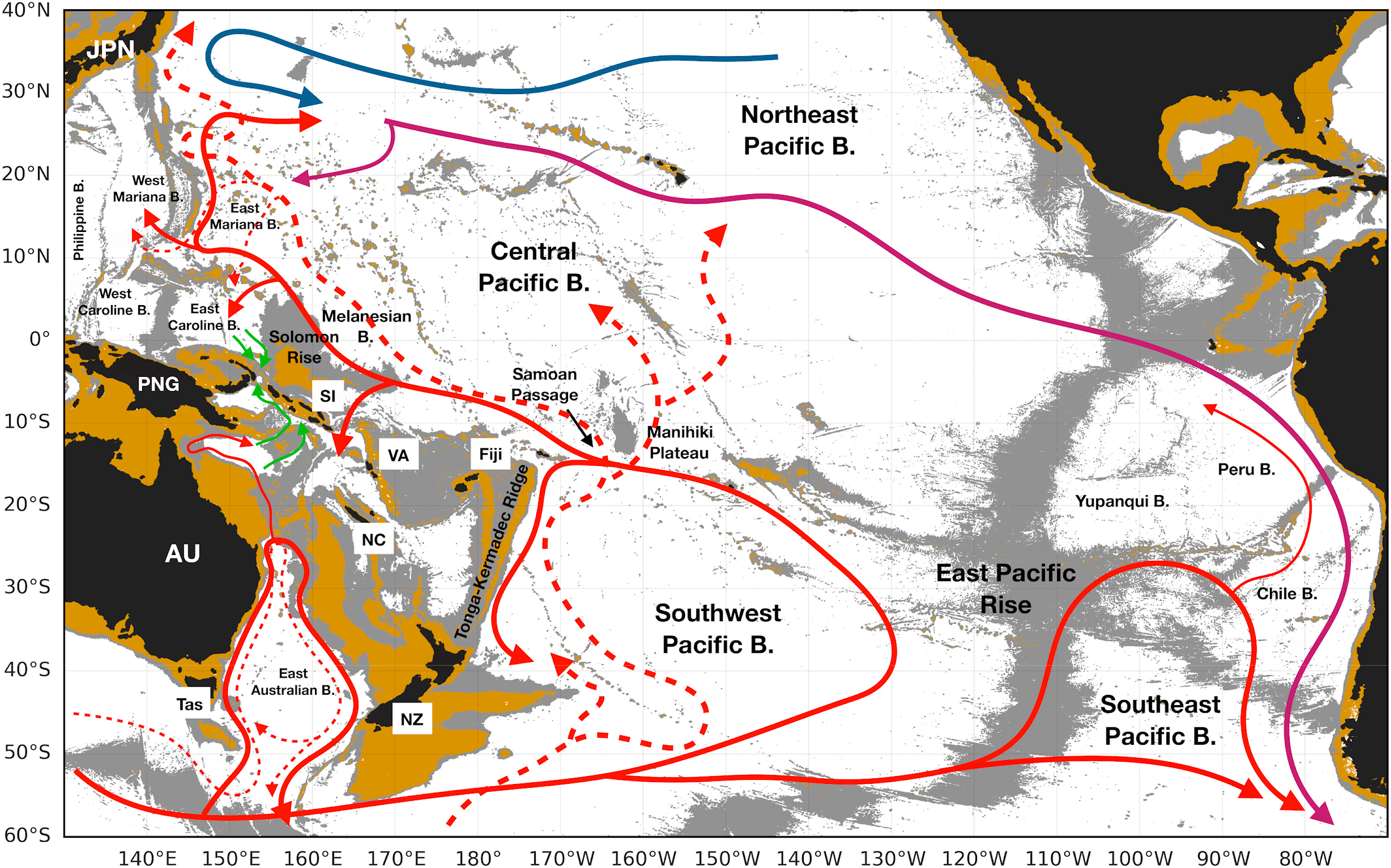
Fig. 1. Map of the Pacific Ocean south of 40°N. Brown shading shows bathymetry above 2000 m; gray shading indicates areas at depths of 2000 to 3500 m from the gridded 15 arc-second General Bathymetric Chart of the Oceans (GEBCO) 2020. Solid red lines with arrows indicate schematic pathways of the Upper Circumpolar Deep Water (UCDW); solid blue line shows the flow of North Pacific Deep Water (NPDW) and solid purple lines indicate modified NPDW flow. These pathways are based on the study of Siedler et al. (2004) and Fig. 2b of Kawabe and Fujio (2010). Paths of the Lower Circumpolar Deep Water (LCDW) are in dashed red lines based on Fig. 2c of Kawabe and Fujio (2010), Fig. 15 of Siedler et al. (2004) and Fig. 16f of Sokolov and Rintoul (2000) in the East Australian Basin, in which the thin solid red line represents the Antarctic Circumpolar Current bottom water (ACCbw). Schematic pathways of UCDW above sill depths into the Solomon Sea Basin (green lines with arrows) based on this study are also indicated. Country/Island names are indicated as follows: Australia (AU); Japan (JPN); New Caledonia (NC); New Zealand (NZ); Papua-New Guinea (PNG); Solomon Islands (SI); Tasmania (Tas) and Vanuatu (VA). Note that B. = Basin.
C. Germineaud, S. Cravatte, J. Sprintall, M.S. Alberty, M. Grenier, A. Ganachaud, (2021). Deep pacific circulation: New insights on pathways through the Solomon Sea, Deep Sea Research Part I: Oceanographic Research Papers, 171(103510), https://doi.org/10.1016/j.dsr.2021.103510.