Moored Observations of Currents and Water Mass Properties between Talaud and Halmahera Islands at the Entrance of the Indonesian Seas
Xiang Li, Dongliang Yuan, Yao Li, Zheng Wang, Jing Wang, Xiaoyue Hu, Ya Yang, Corry Corvianawatie, Dewi Surinati6, Asep Sandra Budiman, Ahmad Bayhaqi, Praditya Avianto, Edi Kusmanto, Priyadi Dwi Santoso, Adi Purwandana, Mochamad Furqon Azis Ismail, Dirhamsyah, and Zainal Arifin
Published in Journal of Physical Oceanography, NOV 2021
The currents and water mass properties at the Pacific entrance of the Indonesian seas are studied using measurements of three subsurface moorings deployed between the Talaud and Halmahera Islands. The moored current meter data show northeastward mean currents toward the Pacific Ocean in the upper 400 m during the nearly 2-yr mooring period, with the maximum velocity in the northern part of the channel. The mean transport between 60- and 300-m depths is estimated to be 10.1–13.2 Sv (1 Sv ≡ 106 m3 s−1) during 2016–17, when all three moorings have measurements. The variability of the along-channel velocity is dominated by low-frequency signals (periods > 150 days), with northeastward variations in boreal winter and southwestward variations in summer in the superposition of the annual and semiannual harmonics. The current variations evidence the seasonal movement of the Mindanao Current retroflection, which is supported by satellite sea level and ocean color data, showing a cyclonic intrusion into the northern Maluku Sea in boreal winter whereas a leaping path occurs north of the Talaud Islands in summer. During Apri–July, the moored CTDs near 200 m show southwestward currents carrying the salty South Pacific Tropical Water into the Maluku Sea.
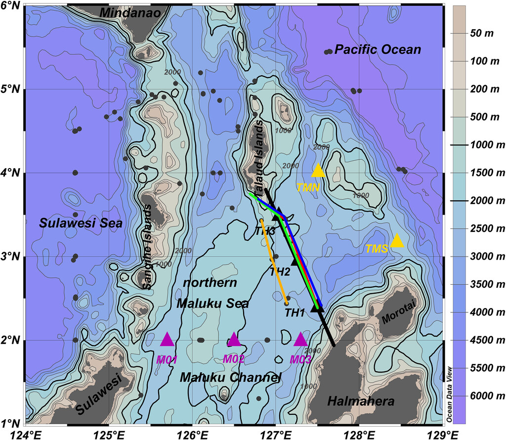
Fig. Bathymetry in the vicinity of the northern Maluku Sea based on ETOPO1 database. The three moorings TH1, TH2, and TH3 in the Talaud–Halmahera Channel used in this study are marked by black triangles. The thick black line across the channel represents the section for transport estimates. Talaud-Morotai North (TMN) and Talaud-Morotai South (TNS) are the mooring locations in Kashino et al. (1999) shown by yellow triangles. The three moorings of the Maluku Channel in Yuan et al. (2018) are shown by purple triangles. The locations of the CTD station and cruise tracks near the TH Channel during the mooring maintenance cruises are marked by dark gray dots and colored lines (orange, 2015; red, 2016; green 2017; blue 2018).
Citation: Journal of Physical Oceanography 51, 12; 10.1175/JPO-D-21-0048.1
Li, X., Yuan, D., Li, Y., Wang, Z., Wang, J., Hu, X., Yang, Y., Corvianawatie, C., Surinati, D., Budiman, A. S., Bayhaqi, A., Avianto, P., Kusmanto, E., Santoso, P. D., Purwandana, A., Azis Ismail, M. F., , & Arifin, Z. (2021). Moored Observations of Currents and Water Mass Properties between Talaud and Halmahera Islands at the Entrance of the Indonesian Seas, Journal of Physical Oceanography, 51(12), 3557-3572. https://journals.ametsoc.org/view/journals/phoc/51/12/JPO-D-21-0048.1.xml